Current Claremont Murders Discussion & Edwards trial updates

Remove this Banner Ad

Status
Not open for further replies.
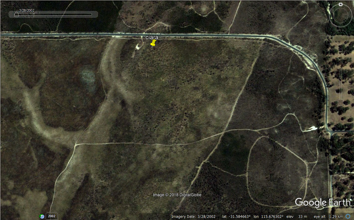
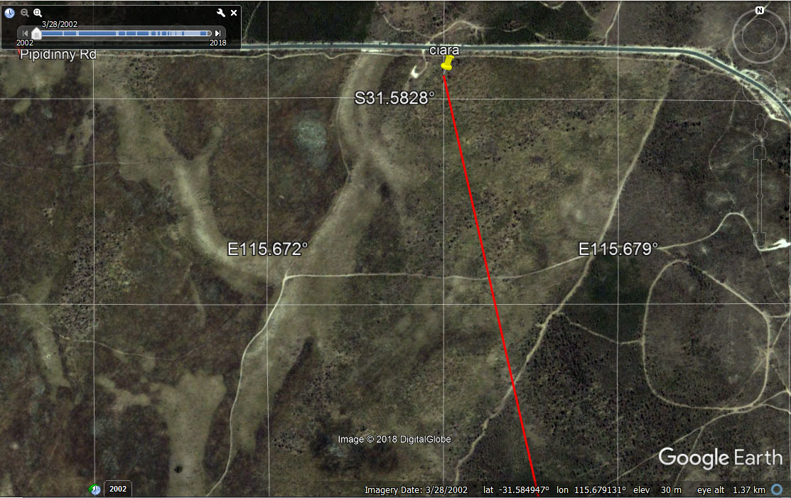
Is the track that can be seen in the photo the one that runs parallel with Pipidinny?

I think it is the outside of the loop on the inward path if that makes sense. (ie. using the pin as the centre the photo is taken from around the 9 o'clock position). I guess it could be from the 12 o'clock as you suggest though.

1547178549326.png
 
I think it is the outside of the loop on the inward path if that makes sense. (ie. using the pin as the centre the photo is taken from around the 9 o'clock position). I guess it could be from the 12 o'clock as you suggest though.

That image is the 2003 raster dataset I believe. The other images posted do denote the ground condition of the day. As you can see, the track is more barren at the time of Ciaras discovery which lends to the fact that the track was whiter and broader at the time of the incident and when the apiarist was in full swing using the track. Whiter and brighter than the 2003 dataset.
 

Log in to remove this ad.

you may require white...on this occasion....
i will explain later...when you see me...

Oh no not white gloves. We will not be checking dust levels in your high security asylum cell bud. Ok keep ya plonk but hand over the meds lol.
 
Although we have had lengthy discussion which suggested the vehicle stopped at the bitumen verge above(I cant remember the reason why now), there is nothing stopping anyone coming up the sand dunes on tracks in a two wheel drive. (Ciara almost exactly 50 metres from the verge give or take a step.)
I won't be surprised if someone went to a nearby warehouse on government road, swapped vehicles to a four wheel drive ute and shot up to Pippidinny.

There were a labyrinth of tracks accessible by 2WD, especially with LSD fitted as standard. One didn't need to come up Pippidinny road.

csk-pipidinny-tracks-2002.jpg
 
Last edited:
I have to help out a friend with a stall at a car show at Claremont showgrounds tomorrow afternoon & into the night. No doubt I'll be lost in my thoughts of what news you guys have found & Imight freak out if I see any small yellow cars
 
That image is the 2003 raster dataset I believe. The other images posted do denote the ground condition of the day. As you can see, the track is more barren at the time of Ciaras discovery which lends to the fact that the track was whiter and broader at the time of the incident and when the apiarist was in full swing using the track. Whiter and brighter than the 2003 dataset.
Yes they do. This one that beat posted above is when the cops were working on the discovery ground. No bee keeper then and rack looks less wide. I seriously doubt any 2 wd could go on any of the sand tracks if they existed then. Entry from the bitumen or 4wd on sandy track. I think Killer Power is correct with the orientation. This sand track that can be seen orientates to the one coming 90 degree off the bitumen. They may have marked the possible route the body was dragged to its resting position.
1547196314186.png
 
Yes they do. This one that beat posted above is when the cops were working on the discovery ground. No bee keeper then and rack looks less wide. I seriously doubt any 2 wd could go on any of the sand tracks if they existed then. Entry from the bitumen or 4wd on sandy track. I think Killer Power is correct with the orientation. This sand track that can be seen orientates to the one coming 90 degree off the bitumen. They may have marked the possible route the body was dragged to its rest

The apiarist was on the other side apparently. No doubt very close to the loop track.

Not where the body was discovered. See how the track is incredibly white on that side as well as opposed to the 2002 dataset when the apiarist felt it wasnt a good idea to stay there.

Wouldnt be surprised if the apiary was centre of the loop at the time. Its why the track was so well used and worn down to bare sand.
 
Last edited:
The apiarist was on the other side apparently. No doubt very close to the loop track.

Not where the body was discovered. See how the track is incredibly white on that side as well as opposed to the 2002 dataset when the apiarist felt it wasnt a good idea to stay there.

Wouldnt be surprised if the apiary was centre of the loop at the time. Its why the track was so well used and worn down to bare sand.
WTF are you talking about? The bee hives wen't there at the time or they would be in the middle of the crime scene. They're there now, almost exactly where the crime scene was. You have a large white patch in your image because you've taken an extreme close up! 1547197780603.png

1547198196863.png
 

(Log in to remove this ad.)

WTF are you talking about? The bee hives wen't there at the time or they would be in the middle of the crime scene. They're there now, almost exactly where the crime scene was. You have a large white patch in your image because you've taken an extreme close up!
View attachment 603843
You're grumpy. Have a rest. You are not thinking clearly. Read the post again.

#campaigner
 
Yes they do. This one that beat posted above is when the cops were working on the discovery ground. No bee keeper then and rack looks less wide. I seriously doubt any 2 wd could go on any of the sand tracks if they existed then. Entry from the bitumen or 4wd on sandy track. I think Killer Power is correct with the orientation. This sand track that can be seen orientates to the one coming 90 degree off the bitumen. They may have marked the possible route the body was dragged to its resting position.
View attachment 603806

Does that then indicate re the markers, the vehicle he drove was hidden behind the bush adjacent to the 1st marker?
 
WTF are you talking about? The bee hives wen't there at the time or they would be in the middle of the crime scene. They're there now, almost exactly where the crime scene was. You have a large white patch in your image because you've taken an extreme close up!View attachment 603836

View attachment 603843
The map data is 2019 and there are 2 separate wheel tracks in the track that is parallel to Pipidinny. This doesnt appear to occur with the right angle track. Would this occur because the parallel track soil had been compacted when the road was sealed before 1997? If yes that takes me back to the photo I 1st commented on taken in 1997 above and that may make that track the parallel track. Hence the remains site was closer to Pipidinny Rd.
 
The map data is 2019 and there are 2 separate wheel tracks in the track that is parallel to Pipidinny. This doesnt appear to occur with the right angle track. Would this occur because the parallel track soil had been compacted when the road was sealed before 1997? If yes that takes me back to the photo I 1st commented on taken in 1997 above and that may make that track the parallel track. Hence the remains site was closer to Pipidinny Rd.

Just replyjng here as a photo in DM book shows the track I thought was the parallel track is definitely the 90 degree track. Oh I see the photos are captioned incorrectly.
 
Oh my goodness I am shocked with what I have just discovered. In the case I am working on I was just checking out Landgate to find an historic aerial and thought I would just look for an aerial taken about the same time as the Claremont girls started disappearing. The closest date for an online aerial is 6 Feb 1995 which just happens to be be about a week before the young girl was abducted from Rowe Park. I am really shocked at what I have found in this Feb aerial.

There is a white car positioned just near the site where Ciara's remains were found in Pipidinny. Of course it may be just someone driving along the road, but hey it maybe a certain individual scoping out the area as well. Its a white car and looks like it has 2 sets of roof racks. I can't make out if it's a station wagon. Any of our 'experts' here care to give it a go to identify make and model?

I have uploaded a screen pic and marked where the bush is that the markers placed by the cops started and a very close approximate as to where Ciara's remains were discovered. How I did that was using a photo in the book I calculated a degree to where you can (just) see the heads of various cops standing near where Ciara's remains were. My degree calc started at the centre of the bush where the cops markers started. It's about 140 from the bush to the remains. The degree from the driver's side door is 120 to the remains.

The straight angled line that appears to cross the road is the shadow of an electrical pole. This same shadow appears in the photo in the book. There were quite dramatic landscape vegetation variations in just over 2 years.

From the Landgate info it appears the discovery site was on land destined to be private. The parcel of land is number (not lot no.) 201 Pipidinny Rd. I always thought this land was just general bushland.

I will post another wide-view aerial in a separate message. landgate 6 2 1995.JPG
 
Here are 2 more wide angle views of Landgate aerial 6 2 1995.
What is of interest is there is another track on the other side of Pipidinny Rd. Why did he put Ciara's remains where he did? Just had a 'thunder thought'. Could Sarah be on this other track? wide ange No2  5 2 1995 landgate.JPG

In these view there are parallel red and yellow lines. I believe these show what was the proposed railway line reserve.
wide angle view 6 2 1995 landgate.JPG
 
How is it I think this person is going to end up in a mental institution of some form, albeit high security with a computer to keep him occupied.
I think your totally wrong & that you keep suggesting it is bewildering to me.
Do you truly believe he is suffering such a hideous & debilitating illness he should be totally devoid of any legal responsibility for his actions if found guilty & he has no awareness of the seriousness of the crimes he is accused of?

Is that how you really feel?

You're fortunate that you've not experienced severe mental illness up close & I know you havent if you believe for a second that someone who is so mentally impaired that killing another person isnt something they realise they shouldn't be doing or they cant comprehend the consequences for doing so or even if they just succumb to the voices egging them on at the time, they're not working fulltime at Telstra or anywhere at all. They're not running little athletics or doing anything else seemingly normal for any length of time either. Nor will their neighbours be surprised & describe them as someone who is friendly but keeps to themselves & nor will they have never come to the attention of the police before.

He wouldnt have been in jail the whole time either, he'd have been transferred to the Frankland Centre while they attempted to get him to a state mentally where they believed he may be able to pull it together enough to even be able to stand trial regardless if he was eventually found criminally responsible or not. Or it would be over already with a trial.*edit without a trial

If you've seen the docile levels some of the mentally ill are medicated to in order to be kept in jail, maybe you'll grasp how sick someone has to be before a judge will ever consider issuing a custody order detaining the accused in a hospital.

Please, a quick brush up on the requirements of the Criminal Law (Mentally Impaired) Act and you'll work out exactly why it wont happen yourself. Theres only 2 provisions that will allow it & they have very specific requirements I guarantee he doesnt meet now and probably never has.

I actually wrote the specific legal considerations out for you once before when you brought it up, but didnt post it. If you'd like to read the most relevant sections in order as it would apply here, I'll find it for you.
 
Last edited:
Here are 2 more wide angle views of Landgate aerial 6 2 1995.
What is of interest is there is another track on the other side of Pipidinny Rd. Why did he put Ciara's remains where he did? Just had a 'thunder thought'. Could Sarah be on this other track?View attachment 604007

In these view there are parallel red and yellow lines. I believe these show what was the proposed railway line reserve.
View attachment 604006
Is this actually 1995? Marmion Ave wasn't extended through Eglington until 2008. It's labeled and looks like a road in your images, but is it just a road or a road reserve?

If it is 1995, I can see the bee hives positioned similar to 2019.
 
Serious questions for you Melsy. With the image you posted for Ciara's discovery.

Did you use google earth in 2018 and go back to 2002?

Could you capture another image zoomed out so we can see the landmarks easier?

Is that a person also captured in the image?
View attachment 604034

I think it is a large tree or Balga Grasstree BlueE

Given the shadow relative to the track width IMO it is too large to be a human.

The dataset says the image is 2002 collection. I am not sure of the accuracy of how it is compiled.
 
BlueE This is supposed to be the broader 2002 dataset. As the years pass, the initial loop track greens over. About 5 years after Cairas discovery.

ciara-location-aerial-pipidinny-wide-csk.jpg
 
BlueE This is supposed to be the broader 2002 dataset. As the years pass, the initial loop track greens over. About 5 years after Cairas discovery.

ciara-location-aerial-pipidinny-wide-csk.jpg
1547279888678.png
This is from 2019 google maps and I used the co-ords from your close up as using the different co-ords above, it would have taken me further away. It doesn't look to be a loop track in the original land gate images Beat has posted from close to the 1996 discovery. Are these Land Gate photos correct time or is there no loop track.

That makes me question what the white smear is in your 2002 closeup? Also would the grass trees would be in the middle of a track and looks to me to have two legs, dark body and a light head, ... a person. What are the chances of that?
1547280359645.png

Area shown from Beat's Land Gate photos from 1996?
1547280457305.png
 
Status
Not open for further replies.

Remove this Banner Ad

Back
Top