Remove this Banner Ad

Education & Reference GD Atlas thread

  • Thread starter Thread starter Shell
  • Start date Start date
  • Tagged users Tagged users None

🥰 Love BigFooty? Join now for free.

Proposed train routes


iu

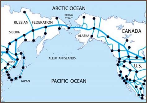
The Bering Strait bridge fascinates me, as if it is completed (along with the Darien Gap in Panama) it would then become theoretically possible to drive from South America to South Africa. Climate change has meant it is easier to deal with the challenge of permafrost and tundra in the region.

However, given the complete lack of roads and railways anywhere near the Bering Strait (I think in the region of 1000+ kms in Alaska), and how much cheaper it is to just stick the stuff you want to send from Asia to North America on a cargo ship, it remains but a mere pipe dream for the next century.
 
When you look at Victoria, South Australia and New South Wales, they all seem pretty connected at first and even look it on maps but, their meeting points actually start in the river. (Murray River presumably.)
 
Officially, Australia has 6 main states and 2 main territories.

Within New South Wales, there lays Jervis Bay Territory.

Isn't Jervis Bay considered part of the Australian Capital Territory?
 

Log in to remove this Banner Ad

When you look at Victoria, South Australia and New South Wales, they all seem pretty connected at first and even look it on maps but, their meeting points actually start in the river. (Murray River presumably.)

Victoria, SA and NSW's borders don't actually all meet at the same place and the eastern border of SA is not a straight line. Due to surveying errors, the SA border is about two miles west of where it should be (if you ask a South Australian) or where it belongs (if you ask a Victorian).

Vic_SA_NSW_border_1883.jpg


Earlier in the week, I discovered a geographical oddity concerning Mooroolbark and Lilydale in Victoria.

Partial copy and paste from my Facebook profile.


Off Mooroolbark Rd, there’s Park Ln.
There’s also Nicholson St.

They’re classified as Lilydale thoroughfares.

Yet, to get to places, both require Mooroolbark Rd to be that conduit.

Mooroolbark Rd forms part of the Mooza B border.

I think I’ve found a suburban exclave.
Or enclave.
I’m not comfortable saying either word yet.


This is one that Catfish Alley would understand more than the others ITT.
 
This is one that Catfish Alley would understand more than the others ITT.

I have no idea! Those road names ring a bell. Mooroolbark Rd is in Mooroolbark until it hits the highway I think. Then It’s Chirnside Park.
 

Attachments

  • Screen Shot 2021-03-06 at 4.45.33 pm.png
    Screen Shot 2021-03-06 at 4.45.33 pm.png
    1 MB · Views: 30
Victoria, SA and NSW's borders don't actually all meet at the same place and the eastern border of SA is not a straight line. Due to surveying errors, the SA border is about two miles west of where it should be (if you ask a South Australian) or where it belongs (if you ask a Victorian).

Vic_SA_NSW_border_1883.jpg


.

with the Covid border closures, there was discussion about the border location. Some little settlements just on the Victorian side were being excluded from the main towns and services on the SA side.

 
Officially, Australia has 6 main states and 2 main territories.

Within New South Wales, there lays Jervis Bay Territory.

Jervis Bay Naval Base/College is annexed to the ACT because Australian Law required every capital city to have a functional seaport

True story
 

Remove this Banner Ad

In prep or maybe prior to prep, I developed a big interest in maps and atlases.

We already had a shared children's atlas that was published by Ladybird.

On Christmas Day 1997, I was given my first atlas.

Coupled with being surrounded by Melway's, it's been an interest of mine 'til this day.
 
It’s not the thread for the debate but I would love Australia to adopt the Indigenous flag. Ours is just real dull. Whack in the southern cross in yellow to match the sun if you have to

I disagree.

And design wise, i just dont like the Aboriginal flag. Or the colours tbh.
 

🥰 Love BigFooty? Join now for free.

It’s not the thread for the debate but I would love Australia to adopt the Indigenous flag. Ours is just real dull. Whack in the southern cross in yellow to match the sun if you have to
I think a lot of people (indigenous and non-indigenous) would have a problem with that

It’s also a bit legally problematic because the copyright for the Aboriginal flag is privately held
 
Carmen Sandiego was my earliest memories of flags i think

We had a big hardback geography book, would've been 2-3 inches thick. I can't remember what it was called but it had a couple of pages at the front with all the flags so that was my first flag resource. Wish I still had it coz it was from the 60s or 70s so would be pretty out of date now.

Also had Carmen Sandiego on 5 1/4 inch floppy back in the day.
 

Remove this Banner Ad

Remove this Banner Ad

🥰 Love BigFooty? Join now for free.

Back
Top Bottom