Navigation
Install the app
How to install the app on iOS
Follow along with the video below to see how to install our site as a web app on your home screen.
Note: This feature may not be available in some browsers.
More options
-


LIVE: St Kilda v Western Bulldogs - 7:30PM Thu
Squiggle tips Saints at 51% chance -- What's your tip? -- Team line-ups »

You are using an out of date browser. It may not display this or other websites correctly.
You should upgrade or use an alternative browser.
You should upgrade or use an alternative browser.
Stats & History The City of Sweet, and the World Around It
- Thread starter Mobbs
- Start date
- Tagged users None

BLERN
Voted 2nd best BLERN on regularsizedfooty
- Oct 13, 2016
- 7,573
- 11,292
- AFL Club
- North Melbourne
well there goes part of my idea. was doing the same thing.
Fizzler
BBTB
- Dec 26, 2013
- 12,749
- 16,332
- AFL Club
- Port Adelaide
- Other Teams
- OKC, Coburg, Werribee, Storm, QPR
Making a map? By all means, go for it. I'm sure there are parts of it that we can both collaborate on. I'll send you what I've done so far.well there goes part of my idea. was doing the same thing.
Restricted Free Agent
President of the Conor Nash fan club
Looking good so far.Making a map? By all means, go for it. I'm sure there are parts of it that we can both collaborate on. I'll send you what I've done so far.
fumbler
Lazy, Very Very Lazy
fumbler
Lazy, Very Very Lazy
Only MInecraft maps now, they hold all the same info and more.
Can you post an updated one on here or email me a copy please?
I want to adapt an overlay of the SPC zones for that timeline of the SFA history.
Mobbs
A Large Portion, Yes
- Thread starter
- #34
I'm likely to make a new one after this round is over. There's been a lot of suburbia fleshing out. I can give a basic screenshot quickly, but adding the suburb delineations etc takes a bit more time. Project for later. I'll willem share it with you once done.Can you post an updated one on here or email me a copy please?
I want to adapt an overlay of the SPC zones for that timeline of the SFA history.
Broken
Brownlow Medallist
Kennedy Parker
🎨𝖆𝖗𝖙𝖎𝖘𝖙🎨

Mobbs
A Large Portion, Yes
- Thread starter
- #37
Kennedy Parker is onto it!
That's the continent of Eksapilani (translates as South Hunting Land)
In this world (well before I'd ever thought of sticking Sweet on it), this continent lagged behind all the others in terms of how much I'd bothered to develop it. So there aren't many towns there, and the one's I'd fashioned, were actually no more than villages.
So there isn't a lot nearby. Rhilpisa is thrown in as the home of Renown Park. There isn't even a developed road network to anywhere else.
Yet.
Mobbs
A Large Portion, Yes
- Thread starter
- #38
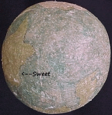
Just to further expand a little. If you try to track the land masses on the globe gif (which is of course direct imaging of an exoplanet and not green- and blue-highlighter on a disco ball's innards), the continent almost attached above is Ricapilani which has quite a few larger centres and a road network. The larger continent on the opposite side (east-west) is Ranutalley (abbrev. Rantalli) which has some very built up areas and some empty, and the southern land is an Australia-esque continent but including further land mass extending all over the south pole (as if Australia and Antarctica were joined), known as Anipor Ballek and where my first fantasy Qooty league is based. Also very built up in most regions but empty down south cos chilly brrr.
There are also a number of island lands around, two further north and a couple in the ocean between Eksapilani and Rantalli, and a couple more even tinier ones.
Ehh, I could go on and on. But ... yeah.
There are also a number of island lands around, two further north and a couple in the ocean between Eksapilani and Rantalli, and a couple more even tinier ones.
Ehh, I could go on and on. But ... yeah.
Broken
Brownlow Medallist
Nice.... I like the open-endedness of that word. Sounds like there's a lot of territory to work with.Yet.
Mobbs
A Large Portion, Yes
- Thread starter
- #40
Here's a bit more that might help in conceiving the world is like, where Sweet resides.
I get a lot of map work done when my computer breaks. Might be soon hahaNice.... I like the open-endedness of that word. Sounds like there's a lot of territory to work with.
Mobbs
A Large Portion, Yes
- Thread starter
- #41
This is a snip from the map KP gave earlier. It's the supposed nation of Hindealla.
Sweet (not shown here, it's from before the Sweet-on-the-map(s) era, would be about where the little dogleg in the coastline is.
The other towns (which are supposed to be the major centres but wouldn't exceed 1000 population in aggregate) are written by hand and probably incomprehensible. They are L
Maprako
Rhilpisa
Shea
Lirmi
Tindoo
The first two are inland. The latter two are coastal.
While all three of national demarcations, rivers and roads are all in the same blue ballpoint, you can probably decipher it. There is a road from Lirmi through Rhilpisa, which hits a t-junction. To the west this new road goes to Maprako. An offshoot road then heads south to Shea. Tindoo has no connectivity shown through the road system.
A major river starts near Shea and mouths at Lirmi. A smaller river system is shown near Tindoo.
A mountain range lines the northern border of the nation.
The numbers are just map numbering for what was hoped one day to be a closer scale.

Edit: I found a small map of a locality called "Tanoca Valley" as well, which isn't on this map. However it is almost certainly located pretty much just north of Tindoo, as Tindoo has two rivers there, and one is called the Tanoca River. Indeed, Tindoo has a little satelltie village called "Lower Tanoca". Yada yada yada
Broken
Brownlow Medallist
Any bigger cities? Larger, or comparable, to Sweet?This is a snip from the map KP gave earlier. It's the supposed nation of Hindealla.
Sweet (not shown here, it's from before the Sweet-on-the-map(s) era, would be about where the little dogleg in the coastline is.
The other towns (which are supposed to be the major centres but wouldn't exceed 1000 population in aggregate) are written by hand and probably incomprehensible. They are L
Maprako
Rhilpisa
Shea
Lirmi
Tindoo
The first two are inland. The latter two are coastal.
While all three of national demarcations, rivers and roads are all in the same blue ballpoint, you can probably decipher it. There is a road from Lirmi through Rhilpisa, which hits a t-junction. To the west this new road goes to Maprako. An offshoot road then heads south to Shea. Tindoo has no connectivity shown through the road system.
A major river starts near Shea and mouths at Lirmi. A smaller river system is shown near Tindoo.
A mountain range lines the northern border of the nation.
The numbers are just map numbering for what was hoped one day to be a closer scale.
View attachment 1090701
Edit: I found a small map of a locality called "Tanoca Valley" as well, which isn't on this map. However it is almost certainly located pretty much just north of Tindoo, as Tindoo has two rivers there, and one is called the Tanoca River. Indeed, Tindoo has a little satelltie village called "Lower Tanoca". Yada yada yada
Mobbs
A Large Portion, Yes
- Thread starter
- #43
Definitely none on that continent.Any bigger cities? Larger, or comparable, to Sweet?
Give me a sec and I'll load my street name database from the planet (which doesn't include Sweet). I can give you a tentative population comparison from the towns on Eksapilani.
All these centres can, of course be further expanded.
Mobbs
A Large Portion, Yes
- Thread starter
- #44
Before I throw all this in here, please note that population is, of course, ESTIMATED.
In fact, to determine population, I simply use a simple mathematical formula based on simple streets numbers in a simple way.
This simply creates a simple population figure with a bit of simple maths.
It's very simple.
Here is the simple formula.
=IF(F431="";"";ABS(IF(F431<VLOOKUP(VLOOKUP($E431;population.factors;4;FALSE());LandUse;3;FALSE());INT(F431*VLOOKUP(VLOOKUP($E431;population.factors;4;FALSE());LandUse;2;FALSE())*(F431/VLOOKUP(VLOOKUP($E431;population.factors;4;FALSE());LandUse;3;FALSE())));F431*VLOOKUP(VLOOKUP($E431;population.factors;4;FALSE());LandUse;2;FALSE()))+LEN($A431)-(IF(ISERROR(FIND("t";$A431));0;FIND("t";$A431))*2))+(ROW()/10000))
Simply put, I am not simply going to break this simple formula down for you. It was developed 10 years ago, and now it's beyond my simple mind. If you want it any simpler, you will simply have to do it for your simple self.
Note :
- "population_factors" refers to a selection which expresses the land use of each "Region", namely Rural, Median or Urban. In Eksapilani, every region has a land use attribution of "Rural", as the towns were all small (prior Sweet). Sweet would certainly qualify as Urban.
- the selection "LandUse" converts these attributions to a multiplier, which is shown here:

My first guess is that I took the number of streets in a place, multiplied it by the x'er, and added the lwr. The rest of the formula was probably just finding each place in the master table, determining whether it was within the selected region (Eksapilani), and - if so - adding them together for a total population.
And now, the population rundown of the globe, which it cannot be stressed enough does not include Sweet because this was all done before Sweet was referred to as a part of this world

So there you have it in a general sense, Eksapilani lists 32 places (excluding Sweet) with a population totalling 16.5k people (excluding Sweet), from a total planetary population (excluding Sweet) of 2.1m people - less than 1% of the global population.
We'd need to come up with a concept of Sweet's projected population to complete this data. I always envisaged Sweet to be somewhere between Bendigo and Geelong in size (essentially maybe about 150k).
BUT the remainder of Eksapilani is low population because I had lapsed in developing it. Smaller towns could have been expanded over time.
Next, I will show the other jurisdiction breakdowns to further expand Hindealla. Nation v Nation is very high-level and doesn't really answer your question. This is just the framework that my answer sits inside, for full disclosure. My next post will tell you more.
Mobbs
A Large Portion, Yes
- Thread starter
- #45
Ok so to explain even more, I treat the "planet" as a whole via an over-arching jurisdiction system which presents as follows :
Level 1 - Global (global totals).
Level 2 - Continental (also includes islands or island groups where appropriate)
Level 3 - National
Level 4 - Regional (smaller nations might have only 1 region)
Level 5 - Ridings (only necessary to further breakdown the largest nations)
As Eksapilani is vastly under-developed, each nation there consists of only one region. Indeed, only one nation consists of more than 1 riding.
Therefore the breakdown into nations and the breakdown into regions is identical, as can be seen here:

As you can see, Hindealla (where Sweet lies) has a population of 3227 as a nation. It has only one region (also called Hindealla, with - of course - the same population). We still haven't drilled it down to what you want, yet.
Next is the breakdown into ridings. Again, it's an under-develped region. However there IS a slight difference. While all other nations have only one riding within their one region, Hindealla has two.

Tindoo and Tanoca is a stand-alone riding from the rest. The assumed "capital" Tindoo is a little more solid, bearing 40% of the national population when combined with the town across the river "Lower Tanoca" and it's upriver neighbour "Tanoca Valley". it's not necessarily the biggest town on the continent, though. As you can see, the nations Gwendehara and Ibarawa have comparable overall populations.
I cannot repeat this often enough : Hindealla now also has Sweet, which is much bigger than ANY of these. It's population if derived by the number of streets could be many thousands, perhaps many tens of thousands. But Sweet has not yet been factored in.
My next and final post will touch upon the potential of Sweet to change this data.
Edit: My computer is now trying hard to die from handling the spreadsheet now, btw. Thanks heaps campaigner.
Level 1 - Global (global totals).
Level 2 - Continental (also includes islands or island groups where appropriate)
Level 3 - National
Level 4 - Regional (smaller nations might have only 1 region)
Level 5 - Ridings (only necessary to further breakdown the largest nations)
As Eksapilani is vastly under-developed, each nation there consists of only one region. Indeed, only one nation consists of more than 1 riding.
Therefore the breakdown into nations and the breakdown into regions is identical, as can be seen here:
As you can see, Hindealla (where Sweet lies) has a population of 3227 as a nation. It has only one region (also called Hindealla, with - of course - the same population). We still haven't drilled it down to what you want, yet.
Next is the breakdown into ridings. Again, it's an under-develped region. However there IS a slight difference. While all other nations have only one riding within their one region, Hindealla has two.
Tindoo and Tanoca is a stand-alone riding from the rest. The assumed "capital" Tindoo is a little more solid, bearing 40% of the national population when combined with the town across the river "Lower Tanoca" and it's upriver neighbour "Tanoca Valley". it's not necessarily the biggest town on the continent, though. As you can see, the nations Gwendehara and Ibarawa have comparable overall populations.
I cannot repeat this often enough : Hindealla now also has Sweet, which is much bigger than ANY of these. It's population if derived by the number of streets could be many thousands, perhaps many tens of thousands. But Sweet has not yet been factored in.
My next and final post will touch upon the potential of Sweet to change this data.
Edit: My computer is now trying hard to die from handling the spreadsheet now, btw. Thanks heaps campaigner.
Mobbs
A Large Portion, Yes
- Thread starter
- #46
Here is a list of all towns on Eksapilani, sorted by Nation. Hindealla is bolded and further indicated by the purple sidebar.
Again, Sweet is NOT here yet. It would far outmatch everything else. Not to mention some additional villages that the work on Sweet created, Tittybong, Coralie, etc.

I will backtrack on saying this is the final descriptive post, because there are other major centres equal in size to Tindoo, and I should explain how far away they are. But its 4pm and I should start breakfast.


Mobbs
A Large Portion, Yes
Similar threads
- Replies
- 18
- Views
- 452
- Replies
- 16
- Views
- 1K
- Replies
- 564
- Views
- 26K
