Remove this Banner Ad

🌀 🌀 Tropical Cyclone Alfred 🌀 🌀 QLD / NSW

🥰 Love BigFooty? Join now for free.

Haven't been told much other than they're monitoring the situation as it happens, just keep all windows closed and refer to the BOM site for info.

A lot of people are checking out
Yet many are staying put.

Others have said they intend on getting on with things. I plan on staying put, yet I've seen Twister I don't want to be a flying cow!
 
Apparently south of the storm eye are going to be hit hardest by wind and rain. Looks like the Gold Coast and Northern NSW are in for a pounding.
Yeah - current forecast has it smack on hitting Bris at 7am Friday, but may drift Southwards as far as Northern NSW. Also 10-15% chance it will be upgraded to a cat 3. While it approaches land, generally west will be wettest, but rainfall will shift to be heaviest on the South side, with Logan almost the epicentre with a 10% chance of 350mm of rain on Fri. Thursday itself won't be the wettest day, Friday and Saturday will be wetter, will quickly lose power when hits the main mainland but will bring massive amount of rain to Brisbane and South and Northern NSW.
 

Log in to remove this Banner Ad


Outside Time Zone Cavil Avenue


I was talking to my cuz last night, and apart from about 10yrs (2012-2022 roughly) when she was in Melbourne, she's predominantly lived in Queensland for more than a few decades - originally down GC way and currently up in Brisbane

She said she's never seen anything like this that she can remember, and trying to explain to people that even if the cyclone downgrades before it hits, there'll still be a significant impact on coastal and beach areas

She did go down to the GC on the weekend, the beaches were already closed but they ventured out to knee deep water - even that shallow she said you could feel the power and she got hit by a wave which wasn't much more than knee height and it knocked her off her feet


Don't blame you for not crossing the road, it's just crazy

I actually couldn't help it and crossed, but stayed well on the footpath. It's real life but feels like a disaster movie.

Did see people on the beach itself this morning. After yesterday when I had that 1st wave at ankle depth, second wave at waist-ish height (and nearly pulled me in + topple me over) I'm water curious but Not stupid enough to do it today.
You want to have a look at https://www.qld.gov.au/environment/coasts-waterways/beach/monitoring/waves-sites/gold-coast
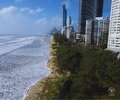
Wave heights at GC have gone from a typical 1.5m to 5.5m and are still climbing
 
I actually couldn't help it and crossed, but stayed well on the footpath. It's real life but feels like a disaster movie.

Did see people on the beach itself this morning. After yesterday when I had that 1st wave at ankle depth, second wave at waist-ish height (and nearly pulled me in + topple me over) I'm water curious but Not stupid enough to do it today.
Head down to Snapper Rocks,they're having fun.
BYO jet ski.


Can't really tell as I didn't zoom in on this instance but where part of the wave finished on the sand... there were a group of 4 standing there seconds before it finished. They ran as it was washing in.

Idiots
 

Remove this Banner Ad

🥰 Love BigFooty? Join now for free.

A Florida resident's take on Cyclone Alfred - please click on the attachments below - note that he was not too concerned, even in a worst-case scenario (effectively Cyclone Alfred being a strong Cat 1/weak Cat 2 on the Simpson-Saffir scale). I personally believe that the US would class this as a strong tropical storm.

As an addendum to this, I spoke to a Florida resident. His words:

View attachment 2241344

View attachment 2241345

Note that a bad Category 3 on the Simpson-Saffir Scale is something akin to Cyclone Larry (maybe fractionally weaker), which occurred 1500 km/h north of Brisbane and which was notoriously destructive.
 
Wind is only 30-40 km/h right now but where I'm staying already sounds like it's going to fly away. A few days ago I spent a lot of time at the indoor pool and that level (close to the ground floor) had A LOT of wind/air swirling around - reminded me of the noise and uneasiness of being at Waverley Park and even the MCG on the winter windy days. The knowledge that the winds will increase to 150+. I'm now realising how serious things will get soon. Things will get loud and vibrations everywhere.

Then there's the whole beachside element, I hope the structure remains standing. I'm now envisioning the building just toppling over at some point. At the very least I hope the roof doesn't get torn off.

Crazy times ahead.
 
Tropical Cyclone Alfred Has Slowed Down & Will Arrive Later - What Does That Mean for SE QLD / NE NSW?

(Key takeaway - you may have awoken to sunny skies this morning Brisbane, but the threat is still there - it's just delayed. And the change in the outlook increases what was already a high concern for rainfall and flooding).

We all held our breath last night as Alfred did a little loop and briefly shifted eastwards, away from the Queensland coastline but this morning we can see that Alfred is most definitely tracking west again with the general progression towards the west today.

It does mean that Alfred will arrive a little later than expected, with a crossing more likely either late tomorrow night, or potentially even during Saturday. When it comes to tropical cyclone movement, tropical cyclones are effectively just big 'sail boats' in the ocean that are pushed around by broader steering influences. But these steering influences are always changing - even a 12 hour delay could lead to a different path.

Because of this delay, by the time Alfred approaches the coastline, the steering influences will likely be weaker - this could see the ridge to the south playing a more significant role, meaning Alfred will slow down on approach to the coastline, possibly hover, do a loop, or just slowly track northwards along the coastline (or a bit of a combination of all these). This is a bit of a double edged sword.

On one hand, it's possible that the maximum wind gust potential is slightly lower - there seems to be more scenarios keeping the strongest (150km/h) wind gusts offshore, or if they do occur being very coastal. On the other hand, it could result in a broader region and longer period of damaging winds (90-120km/h) and a slower moving system has the potential to bring more rain. That rain is very much still focused around northeastern NSW and the southern areas of the Southeast Coast (Gold Coast/Logan catchments etc). But I've mentioned many times about the potential for a post-cyclone convergence line to extend northeast from Alfred and if Alfred slows down, or even wobbles a bit northwards that could mean a longer period of intense rainfall with that rainfall impacting more of the Brisbane metro area.

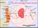
Alfred is well and truly within the BoM's high resolution city model's domain now and have included a wind loop in km/h of the progression. You can see the slow down then shuffle up the coastline - an odd pattern, but it's a scenario we're seeing repeated across many of the models.

It also means the timing of impact could be longer, instead of a Thu - Sat period, we're looking at a Thu-Sun period (mindful that many people in Brisbane this morning will be waking up to sunny skies - trust me, it WILL get worse!) The big thing you'll notice is that when the showers begin to roll through later this morning the winds will become noticeably stronger as the showers drag the stronger winds aloft, down to ground level.
 

Remove this Banner Ad

🌀 🌀 Tropical Cyclone Alfred 🌀 🌀 QLD / NSW

🥰 Love BigFooty? Join now for free.

Back
Top